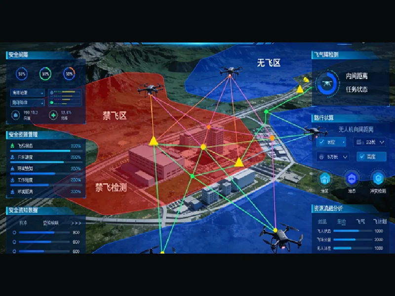
Public agencies exploring drone-based services face a growing coordination challenge: aerial activities must work alongside existing geographic information systems (GIS), command centers, and urban management processes. Selecting the right platform involves more than comparing flight functions. Decision-makers must consider spatial data quality, air-ground integration, operational visibility, interoperability, and long-term maintenance. Icecypress Technology’s Low-Altitude 3D Intelligent Operations Platform offers one approach to connecting these capabilities within a shared digital environment.
Define the Government’s Operational Priorities
Before evaluating vendors, public-sector buyers should identify the problems they intend to address. Municipal authorities may prioritize infrastructure inspection, river monitoring, and urban governance, while emergency services may need rapid spatial information and coordination during disaster response.
These use cases require different combinations of data, equipment, and workflows. A procurement team should document the geographical coverage, participating departments, expected outputs, operating hours, and existing systems that must connect to the proposed platform.
This assessment also helps distinguish immediate needs from future ambitions. A focused pilot covering a priority district or a specific public service can provide practical evidence before a larger regional deployment is considered.
Evaluate the Core Capabilities of a Low-Altitude Platform
A low-altitude platform should offer capabilities beyond a map displaying drone locations. Public agencies need a coherent view of airspace, geographic features, flight activities, and relevant operational information.
Icecypress Technology’s Low-Altitude 3D Intelligent Operations Platform combines three core capabilities: high-fidelity 3D spatial data, integrated air-ground operations, and connected operational services. Its spatial foundation brings together remote sensing imagery, real-scene 3D models, and airspace information.
The platform also connects aerial and ground-based information within a shared spatial framework. This structure supports applications across urban governance, emergency response, inspection, and logistics, allowing agencies to evaluate several use cases around a common digital foundation rather than separate, disconnected projects.
During vendor assessment, buyers should request demonstrations using representative local data. They should examine how users access spatial information, review operational activity, and produce outputs relevant to their responsibilities.
Prioritize Integration with Existing Smart City Systems
Public-sector technology procurement rarely happens in isolation. Municipalities may already operate GIS databases, surveillance systems, emergency command centers, and departmental information platforms. Introducing another system without a clear integration plan can create duplicated data and additional administrative work.
Icecypress Technology’s platform is designed to extend existing smart city environments with low-altitude spatial data, flight information, and operational alerts. Supported geospatial outputs include digital elevation models (DEM), digital surface models (DSM), digital orthophotos (DOM), and true digital orthophotos (TDOM).
These outputs can be incorporated into established GIS and command-center workflows, subject to the receiving system’s compatibility requirements. Configured operational alerts can also be passed to relevant departments for follow-up.
Procurement teams should verify supported interfaces, data formats, access permissions, cybersecurity requirements, and responsibility for system maintenance. A successful integration plan should explain how information moves between systems and which department owns each stage of the workflow.
Assess Monitoring, Coordination, and Public-Service Needs
A platform intended for public administration should help authorized personnel understand operational conditions and coordinate responses across departments. Its value depends partly on whether relevant information reaches the people responsible for acting on it.
When assessing low-altitude operational solutions, buyers should examine how the platform presents air-ground information, flight activity, spatial context, and configured alerts. They should also clarify which monitoring functions apply to the proposed deployment and what infrastructure those functions require.
The Icecypress platform supports continuous monitoring configurations for designated areas, including arrangements designed for 24-hour coverage. Such deployments can complement existing urban-management and security workflows, although coverage and response arrangements depend on project configuration.
Public agencies should establish clear procedures for alert verification, escalation, incident documentation, and interdepartmental communication. Technical visibility alone does not replace operational policies, trained personnel, or applicable aviation regulations.
Plan Procurement in Phases and Measure Results
Large-scale deployment across an entire city may involve substantial data preparation, integration work, staff training, and ongoing operating costs. A phased approach allows agencies to assess these requirements before expanding coverage.
Icecypress Technology supports phased implementation, beginning with priority areas and selected scenarios before extending the deployment. For example, a municipality could initially focus on river monitoring or municipal infrastructure inspection, then evaluate whether the same spatial foundation can support additional departments.
Evaluation criteria should be measurable and connected to public-service objectives. Useful indicators include geographic coverage, data-update frequency, alert handling time, system availability, interoperability, and staff workload. Buyers should establish baseline values and agree on acceptance criteria before the pilot begins.
A full procurement assessment should also cover licensing, infrastructure, data governance, maintenance responsibilities, service support, and future expansion costs. These considerations help agencies compare proposals on lifecycle value rather than initial purchase price alone.
Building a Practical Foundation for Public-Sector Operations
Choosing among low-altitude operational solutions requires a clear understanding of local priorities, integration constraints, and long-term service responsibilities. Public agencies should evaluate spatial data, operational visibility, interoperability, implementation plans, and measurable outcomes before committing to a regional deployment.
Icecypress Technology’s Low-Altitude 3D Intelligent Operations Platform is worth evaluating for projects that require integrated 3D spatial information, air-ground coordination, and connections to existing smart city systems. A carefully scoped pilot can help decision-makers determine whether the platform fits their technical environment and service objectives. With defined requirements and transparent evaluation criteria, a low-altitude platform can become a useful part of public-sector digital infrastructure.
